WestConnex M4 East Environmental Impact Statement
September 2015
Prepared for WestConnex Delivery Authority
Prepared by AECOM Australia Pty Ltd, GHD Pty Ltd
4 Project development and alternatives
This chapter describes the alternatives that were considered as part of the development process for the M4 East project (the project), and explains how and why the project was selected as the preferred option. Design options and refinements for particular elements of the project are also addressed.
The Secretary of the Department of Planning and Environment has issued a set of environmental assessment requirements for the project; these are referred to as Secretary’s Environmental Assessment Requirements (SEARs). Table 4.1 sets out the Secretary’s Environmental Assessment Requirements that relate to project development and alternatives, and identifies where these have been addressed in this environmental impact statement (EIS).
| Secretary’s Environmental Assessment Requirement | Where addressed in the EIS |
|---|---|
[A]n analysis of feasible alternatives to the carrying out of the project and project justification, including:
|
Chapter 4 (this chapter)
Public interest is addressed in Chapter 30 (Project justification and conclusion). |
4.1 History of the M4 East and WestConnex
It has been acknowledged that no single project provides a complete solution to Sydney’s transport requirements. Variations on the component projects of WestConnex have been under consideration since the early 2000s and would augment and complete missing links in Sydney’s motorway network.
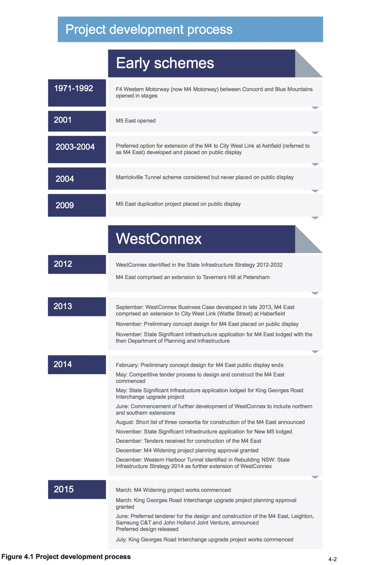
Figure 4.1 shows the project development process undertaken for theM4 East and WestConnex.
4.1.1 M4 Motorway
The construction of the M4 Motorway (originally the F4 Western Freeway) occurred in several stages between the late 1960s and the mid-1980s. It was first opened to traffic in 1971 and now comprises a 40 kilometre urban motorway connecting Concord with the Blue Mountains. The section between Parramatta and Concord was opened in 1992. Since then, various schemes and multiple options have been explored, developed and built to complement the M4.
Between 2003 and 2004 a preferred option for an eastern extension of the M4 to the Sydney central business district (CBD) was developed and publicly exhibited. This option, referred to as the M4 East, proposed extending the M4 to the City West Link and Parramatta Road at Ashfield as well as widening the existing motorway between Homebush Bay Drive and Concord Road. This scheme was put on hold indefinitely by the then NSW Government. The 2003 preferred option formed the basis of the concept design for the M4 East project, which forms part of WestConnex. The M4 Widening, which forms part of WestConnex, will upgrade the M4 to general y four lanes in each direction between Pitt Street at Parramatta and Homebush Bay Drive at Homebush. As discussed in section 4.1.4, planning approval for the M4 Widening was granted in December 2014 and work began in March 2015.
4.1.2 M5 East Motorway
The M5 East Motorway is a 10 kilometre motorway connecting the M5 South West Motorway with General Holmes Drive and the Eastern Distributor. The M5 East opened in 2001 and from this time has operated at or near capacity. The M5 East Motorway has attracted ongoing community concern in relation to tunnel air quality.
A proposal for the M5 East duplication was publicly displayed in 2009. Since that time the scheme has undergone further development and now forms part of WestConnex – King Georges Road Interchange Upgrade and New M5 (King Georges Road at Beverly Hills to St Peters).
4.1.3 Connection between the M4 and M5 East
The Marrickville Tunnel was a scheme considered in around 2004 to create a direct connection between the then M4 East and Mascot, in order to provide a direct route for traffic between Port Botany, Sydney Airport and South Sydney. One option considered for this scheme was a truck only tunnel, recognising that the main function of this link would be to enhance freight access between Port Botany, Sydney Airport and north-western Sydney. This scheme was not progressed and was never placed on public display. The Enfield Intermodal Terminal was then developed instead to increase the volume of freight carried by rail to and from Port Botany, with distribution by road from Enfield using existing arterial roads and the M4.
The concept of a connection between the M4 and M5 East has developed to become the possible future M4–M5 Link (M4–M5 Link) which, subject to planning approval, forms part of WestConnex. This would complete the orbital road network between western Sydney and the eastern gateways of Port Botany and Sydney Airport, and provide a north–south bypass of the Sydney CBD.
4.1.4 WestConnex and M4 East
WestConnex has evolved from the earlier schemes for the M4, M5 East and the connection between the two. It is aimed at enhancing the capacity and connectivity of the M4 and M5 East motorways. The WestConnex scheme was first set out in the State Infrastructure Strategy 2012-2032 (Infrastructure NSW 2012a) as a strategic concept, developed as a response to a series of strategic challenges faced by Sydney and NSW.
The State Infrastructure Strategy identified the component projects of WestConnex to be delivered in two stages:
- Northern Sector, comprising widening of the existing M4 (now M4 Widening) and M4 Extension to Taverners Hill and St Peters (now M4 East and M4–M5 Link)
-
Southern Sector, comprising the M5 East Expansion (now New M5 and King Georges Road Interchange Upgrade).
The ‘M4 Extension’ component of WestConnex comprised a connection between the existing M4 at Concord and Taverners Hill in Petersham (Infrastructure NSW 2012b). The M4 Extension was to be constructed in sections variously in tunnel, in cutting (or ‘slot’), at grade or on elevated road, to optimise urban renewal along Parramatta Road.
To reduce risks and costs, NSW Roads and Maritime Services (Roads and Maritime) engaged leading Australian and international construction industry partners to review and optimise the design (as developed to 2013) along with earlier works for the WestConnex scheme, and to develop innovative solutions for different forms of alignment options. The outcome of this work was incorporated into the project design development and assessment.
In September 2013, the WestConnex Business Case Executive Summary was released (Sydney Motorways Project Office 2013a). The Business Case Executive Summary identified the component projects of WestConnex to be delivered in three stages:
- Stage 1: Parramatta to Haberfield (now M4 Widening and M4 East)
-
Stage 2: Beverly Hills to St Peters (now King Georges Road Interchange Upgrade and New M5)
-
Stage 3: Haberfield to St Peters (now M4–M5 Link).
The M4 East component of WestConnex was proposed to continue the M4 from Homebush Bay Drive to Parramatta Road and City West Link at Haberfield, by providing a tunnel with three lanes in each direction, general y following the alignment of Parramatta Road. The preliminary concept design for the M4 East was publicly displayed between November 2013 and February 2014. Submissions received during the public display were considered and informed the development of the M4 East concept design.
A competitive tender process to design and construct the M4 East commenced in May 2014, when expressions of interest were called. A shortlist of three consortia to build the M4 East was announced by the NSW Government in August 2014. Tenders from shortlisted contractors to build the M4 East were received in December 2014, and tender evaluation and design refinement to cater for changes to WestConnex as described below took place over the first half of 2015. The preferred tenderer, a consortium comprising Leighton, Samsung C&T and John Holland, was announced on 4 June 2015.
Concurrent with the design and construct tender process, in June 2014, the NSW Government requested that the WestConnex Delivery Authority (WDA) assess the potential for enhancing the scope of WestConnex through northern and southern extensions to the scheme. The northern extension is proposed as a link to the former Rozelle Goods Yards, enabling connection to the Victoria Road corridor to the north and Anzac Bridge and Western Distributor to the east. The southern extension is proposed as a connection between the proposed New M5 tunnels (to be built as part of WestConnex) and President Avenue at Rockdale. WDA is currently developing a business case for the northern and southern extensions that sets out their strategic and economic rationale and indicates a path for their further development. The northern and southern extensions are shown in Figure 1.2 in Chapter 1 (Introduction).
In addition to the northern and southern extensions of WestConnex, Rebuilding NSW: State Infrastructure Strategy 2014 (NSW Government 2014b) identifies the proposed Western Harbour Tunnel project as the next major motorway to be developed after or at the same time as the M4–M5 Link. It would see the construction of an additional Sydney Harbour road crossing of approximately seven kilometres, connecting the WestConnex northern extension around Rozelle with the Gore Hill or Warringah freeways. Feasibility work and business case development for the project is underway. Together, the WestConnex extensions and the Western Harbour Tunnel would facilitate a new northísouth route through Sydney that avoids the Sydney Harbour Bridge and Tunnel, CBD, Eastern Distributor and Anzac Bridge.
The status of the other component projects of WestConnex is as follows:
- A planning application was made for the New M5 in November 2014 and an EIS is currently being prepared
-
Planning approval for the M4 Widening was granted on 21 December 2014 and work began in March 2015
-
Planning approval for the King Georges Road Interchange Upgrade was granted on 3 March 2015 and work began in July 2015
-
A separate planning application will be made for the M4–M5 Link following further concept development.
4.2 Strategic alternatives
The merits of the project were considered by WDA and Roads and Maritime in the context of a range of other alternatives. The alternatives considered are consistent with those considered for other recent motorway upgrade and enhancement projects in the Sydney metropolitan area. Alternatives to the project were considered based on the extent to which they could meet the project objectives and how well they performed with reference to other transport, environmental, engineering, social and economic factors.
The following strategic alternatives to the project were considered:
- Alternative 1 – the base case or ‘do nothing/do minimum’ (‘do minimum’)
-
Alternative 2 – improvements to the existing arterial road network
-
Alternative 3 – investment in public transport and freight rail improvements
-
Alternative 4 – demand management
-
Alternative 5 – extension of the M4 as part of WestConnex.
These alternatives are described below.
4.2.1 Alternative 1 – Base case or ‘do nothing/do minimum’
The base case ‘do nothing/do minimum’ option (‘do minimum’) would involve retaining the M4 (with the M4 Widening completed) and Parramatta Road, in essentially its current configuration, as the main eastíwest route between Western Sydney and Haberfield. The M4 between Church Street at Parramatta and Homebush Bay Drive at Homebush would be a tolled motorway as part of the ‘do minimum’ option. Only minimal new infrastructure such as routine road network and intersection upgrades would be provided over time to improve capacity.
Future transport demand in the Parramatta Road corridor represents a significant chal enge for Sydney and NSW. Parramatta Road has one of the highest number of bus passengers, during the morning peak, of any major bus route in Metropolitan Sydney. Road congestion on Parramatta Road has led to bus services using the road being delayed and unreliable (ie not running to timetable).
Sections of Parramatta Road carry more than 90,000 vehicles each day, with up to 6,000 of these being heavy vehicles (refer to section 8.2.2 in Chapter 8 (Traffic and transport)). On an average weekday, 2.8 million trips start or finish within the Parramatta Road corridor. This represents 14 per cent of all trips made within Sydney daily. The locations with highest traffic volumes are between the end of the M4 at Concord and Wattle Street. Average travel speeds of private vehicles during the morning peak are about 30 kilometres an hour (Transport for NSW 2012a). Without the project, Parramatta Road would continue to operate at and beyond capacity in peak hours.
The current network does not support a growing population that needs to efficiently and reliably access dispersed employment areas and services. Currently, road congestion costs NSW $5.1 billion each year, due largely to time delays. This figure is expected to increase to $8.8 billion by 2020 (Transport for NSW 2012a). If no improvements are made to this corridor, traffic model forecasts show that travel times between Strathfield and the Sydney CBD will continue to increase, even assuming the implementation of the various public transport improvements currently planned or under construction. Without the project, congestion on Parramatta Road will continue to impact on the NSW economy through longer delivery and transport times in Sydney, and particularly for businesses in Western Sydney.
Traffic modelling under the ‘do minimum’ scenario indicates that, by 2031, morning peak travel times between Homebush Bay Drive at Sydney Olympic Park and Flood Street at Leichhardt would increase by about 17 minutes in the westbound direction and by less than two minutes in the eastbound direction. In the afternoon peak, travel times in both directions would increase by between five and eight minutes.
Summary
In the context of the transport challenges identified in Chapter 3 (Strategic context and project need), a ‘do minimum’ option is considered unrealistic and would not address a number of Australian and NSW government commitments, including key goals in NSW 2021: A Plan to Make NSW Number One (NSW Department of Premier and Cabinet 2011) (see section 3.1). It would also not meet the project objectives as outlined in section 3.3.
4.2.2 Alternative 2 – Improvements to the existing arterial road network
Infrastructure NSW recognises that the wider road network, including major arterials, will also require improvement and that some of the highest value infrastructure investments come from ‘pinch point’ relief that addresses road congestion ‘hotspots’ (Infrastructure NSW 2012a). Improvements to the existing arterial road network are seen as complementary to the project objectives, reinforcing the function of the arterial road network as providing high order access routes to the broader road network, as distinct from the long distance through route function performed by Sydney’s motorway network.
Improvements to Parramatta Road
Consideration was given to upgrading Parramatta Road to improve traffic flow and reduce congestion. These works would likely include multiple improvements to roads and intersections along the Parramatta Road corridor and Parramatta Road itself, in an attempt to maintain an acceptable level of traffic operation.
Parramatta Road east of the intersection with the existing M4 generally experiences high levels of congestion during much of the day, including on weekends. As such, localised intersection improvements, refinements to traffic signal timing and/or phasing, road safety measures or similar small scale works may provide some improvement to travel times and would have an acceptable level of traffic impacts during their construction phase. More substantial improvements would likely require grade separation of intersections, which would have substantial traffic impacts during construction. These measures would still only manage current congestion issues, rather than catering for future demands related to increased traffic volumes and improved public transport, such as the planned bus rapid transit or light rail service. These demands could only be accommodated by providing additional lanes along the length of Parramatta Road. Construction of additional lanes would likely require considerable private property acquisition along the length of Parramatta Road.
Improvements to Patterson Street, Gipps Street, Queens Road and Ramsay Road
Patterson Street, Gipps Street, Queens Road and Ramsay Road provide an alternative road corridor between the end of the M4 at Concord and Wattle Street (City West Link) at Haberfield. Existing congestion on Parramatta Road between Concord Road and Wattle Street causes drivers to use these local roads as an alternative route. These roads are generally one lane in each direction, with Queens Road carrying up to 27,325 vehicles during an average weekday (refer to section 8.2.2 of Chapter 8 (Traffic and transport)).
Substantial improvements to these roads would require considerable private property acquisition and removal of dedicated cycle lanes to accommodate additional traffic lanes. The amenity and safety of pedestrians and cyclists using these roads would likely be reduced as a result of traffic, noise and air quality impacts.
In addition, increasing the traffic capacity of these roads would further restrict northísouth movements across the Parramatta Road corridor, as the dominant traffic flow would be eastíwest movements. This would not meet the project objective to enhance northísouth movements across the Parramatta Road corridor.
Improvements to Victoria Road
Victoria Road provides an alternative transport corridor from Parramatta to the Sydney CBD north of the Parramatta River. The character of this route differs from the M4 and Parramatta Road corridor because its topography is much more varied, with steeper slopes and tight bends. The Victoria Road corridor passes through a number of established centres and crosses major natural features and service/transport infrastructure, which presents significant chal enges for increasing road capacity.
Improvements to the Victoria Road corridor would not meet the M4 East project objectives. They would not enhance movements across the Parramatta Road corridor, nor would they create opportunities for urban revitalisation, improved liveability, and public and active transport improvements along and around Parramatta Road.
Similar to the option to improve the Parramatta Road corridor, substantial improvements to Victoria Road would likely require grade separation of intersections, which would have substantial traffic impacts. These measures would still only manage current congestion issues rather than catering for the future traffic demands expected in these corridors. Construction would also likely require removal of bus lanes and/or considerable private property acquisition along the length of Victoria Road to accommodate additional general traffic lanes.
Summary
The arterial road improvement alternatives described in the preceding sections are considered inadequate responses to the significant transport challenges on the Parramatta Road corridor. Localised road corridor improvements would only provide an incremental change to the network, rather than supporting the additional capacity required for improved bus services and regional traffic growth.
For alternatives to be worthy of consideration, they must be broadly capable of accommodating the identified transport task and challenges being addressed by WestConnex. These can only be met by major arterial road improvements that will have significant construction impacts or require the construction of new infrastructure. Arterial road improvement options would therefore not meet the project objectives as outlined in section 3.3 of Chapter 3 (Strategic context and project need).
4.2.3 Alternative 3 – Investment in public transport and rail freight improvements
As discussed in Chapter 3, WestConnex is a key component of the NSW Long Term Transport Master Plan (Transport for NSW 2012a) (Transport Master Plan), the State Infrastructure Strategy 2012–2032 (Infrastructure NSW 2012a) (State Infrastructure Strategy) and A Plan for Growing Sydney (NSW Government 2014a). As part of a broader integrated transport solution, the project supports a coordinated approach to the management of freight and passenger movements, as well as all modes of transport including road, rail, bus, ferries, light rail, cycling and walking. There is, however, recognition that Sydney’s freight, commercial and services tasks require distribution of goods and services across the Sydney basin, which relies on more diverse and dispersed point-to- point transport connections that can only be provided by the road network.
Public transport
The Parramatta Road corridor runs paral el to the Main Western Rail Line. Trains provide the trunk public transport service in this corridor, connecting Western Sydney and centres in the corridor to the Sydney CBD. Sydney’s Rail Future (Transport for NSW 2012b) identified the need for service improvements on the Main Western Rail Line, which are being considered separately by the NSW Government. Sydney’s Rail Future also outlines the establishment of Sydney Rapid Transit (now Sydney Metro) which, while not directly servicing the Parramatta Road corridor, would assist in removing some key bottlenecks on the Sydney Trains network. This would then improve train movements along the Main Western Rail Line.
Commercial and retail centres have developed around stations along the Main Western Rail Line, including at Strathfield, Burwood and Ashfield. Consequently, many bus services on and around the Parramatta Road corridor act as feeder services to train stations and centres, although there remains a strong demand for eastíwest services along Parramatta Road between Burwood and the Sydney CBD.
Public transport options such as rail, light rail or bus would be feasible potential alternatives if the project, as part of WestConnex, was primarily concerned with transporting people to and from centres. However, the key customer markets identified for the project include highly dispersed and long distance passenger movements, as well as heavy and light freight and commercial services and businesses whose travel patterns are also greatly dispersed and diverse in nature. These customers have highly varied requirements when it comes to the transfer of goods and services. These requirements include the transport of containerised freight by rigid and articulated trucks, light trucks, vans, utility vehicles and cars.
Public transport would only partially address these customer demands. There are no feasible strategic transport alternatives í such as heavy or light rail options or bus corridor enhancements í that would meet the diverse range of customer needs for travel in this corridor and address the project objectives as effectively as the project and WestConnex more broadly.
This does not preclude a number of these public transport alternatives being complementary to the project and the broader WestConnex scheme. In particular, the project is expected to reduce traffic volumes along Parramatta Road. As described in Chapter 3 (Strategic context and project need), this would allow for the establishment of a mass transit corridor along Parramatta Road, and the project has been designed to allow for the provision of this mass transit corridor (refer to section 5.5.5 (Project Description)). Such a corridor would provide suitable facilities for the transport of a high number of people along Parramatta Road by bus. In the long term and as outlined in Sydney’s Bus Future (Transport for NSW 2013a), if demand permits, this corridor could be upgraded to light rail.
Combined transport options
A ‘park and ride’ scenario, supplemented with a light rail line along Parramatta Road or express heavy rail services to Central Station, has been identified by a public transport advocacy group known as Eco-Transit. This transport alternative would introduce a ‘park and ride’ facility and busírail interchange in Olympic Park, an additional railway station on the Olympic Rail Line near its crossing of the existing M4, and an express service linking the new station with Central Station via the Main Western Rail Line. The park and ride facility would be supplemented by a light rail line from this new station, along Parramatta Road to Central Station.
Passenger trips for work, education, health, recreation and personal business are recognised as a key customer market on the M4 East. A majority of these trips are by private vehicle, as many destinations are located outside the major centres. Commuting and education trips typically occur in the morning and afternoon travel peaks, whereas other passenger trips are more discretionary and can occur in inter-peak times and on weekends. These trips are typically highly dispersed and travel patterns are complex.
Public transport is not the most effective way of servicing a majority of these passenger trips. It also fails to address demand for the movement of freight and trades and services. For these reasons, public transport options are seen as complementary services supporting, but not whol y able to address, the transport demands that would be addressed by the project and the broader WestConnex scheme.
Rail freight
Apart from moving passengers, Sydney’s rail network plays a significant role in moving freight between Sydney’s ports and destinations around Sydney, regional NSW and other states. The Trade and Logistics Report 2011-12 (Sydney Ports Corporation 2012) indicates that some 98 per cent of imported containers and over 60 per cent of exported containers through Port Botany have their origin and destination within Greater Sydney.
The Transport Master Plan identifies a number of current and future freight-related projects that complement the existing freight network. These include:
- Completion of the Southern Sydney Freight Line
-
Development of an intermodal terminal at Enfield (commenced limited operation in March 2015 with some construction work ongoing)
-
Stage one of the Northern Sydney Freight Corridor Program (under construction)
-
Development of an intermodal terminal at Moorebank (in planning approval phase)
-
A Western Sydney Freight Line (corridor for future preservation under investigation)
-
Western Sydney Intermodal Terminal (sites being considered as part of investigation for the Western Sydney Freight Line).
There are opportunities to shift more freight onto rail, and this remains a priority for the NSW Government. However, assuming the target of doubling the share of container freight moved by rail is achieved by 2020 (Transport for NSW 2013d), more than 70 per cent of Port Botany’s projected trade would still be moved by road, requiring investment in an efficient road network to support the port and airport precincts.
Rail freight transport is more effective for long distance transport of goods to regional centres. However, Sydney’s freight, service and business task requiring distribution within the Sydney metropolitan area relies on dispersed point-to-point transport connections to customers. Predominantly, freight rail serves the first leg of the freight journey, with containerised freight broken down at distribution nodes and further distributed across Sydney. In managing the freight task, heavy commercial vehicles require a primary network with high quality connections between major freight hubs, whereas light commercial vehicles depend on a multi-layered network with many connections to service more diverse and dispersed markets across Sydney.
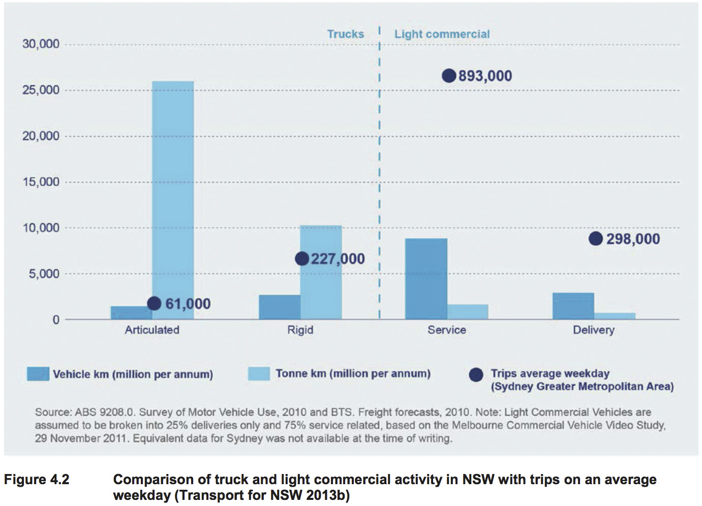
This arrangement means that there are around four times as many light commercial vehicle trips on Sydney’s road network as heavy commercial vehicle trips (Transport for NSW 2013b) (refer to Figure 4.2), and this trend is forecast to continue. A key reason for this trend is that heavy freight activity precincts are concentrated in a few key locations in the vicinity of the port and across Western Sydney, and this land use pattern is also set to continue into the future.
The Sydney Airport Master Plan 2033 (Sydney Airport Corporation Limited 2014) notes that Sydney Airport handles about half of Australia’s international air freight. The total amount of freight handled at Sydney Airport is 76 per cent more than any other Australian airport. The volume of freight handled by Sydney Airport is projected to increase from 615,378 tonnes in 2012 to 1,011,312 tonnes in 2033 (Sydney Airport Corporation Limited 2014). Air freight exports from Australia are dominated by fresh, chilled or frozen perishables such as meat, seafood, fruit, vegetables, flowers, livestock and manufactured goods.
A key location for supply and re-distribution of fresh, chilled or frozen perishables in Sydney is the Sydney Markets at Flemington, adjacent to the M4 at Homebush. These time-critical exports rely on productive, efficient and effective landside and airside logistics that are best met by road rather than rail. Rail freight transport remains reliant on road transport to move freight to a train from the source, and from the train to the final destination. In Sydney, road transport provides a direct link between the source of the produce (eg regional areas) and the Sydney Markets, and from the markets to retail outlets as well as Sydney Airport.
The development of the Western Sydney Airport has the potential to change the way some freight is moved around Sydney, by providing an alternative entry or exit point for freight. Overall, however, the movement of freight around Sydney is not considered to be significantly altered by the introduction of the new airport, for the following reasons:
- The operation of the Western Sydney Airport would be staged, ramping up over time, with initial operations only commencing in the mid-2020s (a minimum of five years after the completion of the project)
-
Freight arriving at the new airport would still have destinations across wider Sydney
-
Port Botany and Sydney Airport would still be key freight entry and exit points, with the new airport to complement the existing airport.
In combination with the freight-related projects identified above, the project and the broader WestConnex scheme would provide a robust freight solution and would best address the project objectives.
Summary
There are no feasible strategic public transport or rail freight alternatives that would fully meet the diverse range of needs for travel in the Parramatta Road corridor, and address the project objectives as outlined in section 3.3. Public transport and rail freight options are seen as complementary services supporting the project and the broader WestConnex scheme, and the NSW Government is currently implementing a number of public transport and rail freight projects.
4.2.4 Alternative 4 – Demand management
Demand management can be defined as a policy, planning and operational approach to the movement of goods or people. Demand management encompasses policies intended to reduce individual trips and make various mode options more viable. These policies include:
- Urban consolidation and ‘centres’ policies (land use planning) to reduce the need for travel
-
Other planning control policies such as restricting parking provisions in new developments
-
Road network management and network connectivity policies, including implementation of intelligent transport systems to improve public transport operation, management of clearways and transit lanes, and providing greater priority for public transport over general traffic
-
Transport pricing to reduce travel demand; including demand based, tolling or transport pricing to discourage discretionary travel by private vehicle for trips that can be served by public transport.
The Transport Master Plan highlights that Western Sydney is currently home to 47 per cent of Sydney’s residents but only 37 per cent of Sydney’s jobs (Transport for NSW 2012a). This disparity is due to a number of factors that include greater housing affordability in Sydney’s west, and the existing agglomerations and infrastructure that support stronger business investment (and therefore location decisions) in the global economic corridor and Sydney’s east more generally.
Demand management measures can take many years to achieve changes in travel behaviour, as existing customer practices need to be modified and existing investment priorities changed. In the context of this project, travel demand management would require modifying travel decisions and reducing dependence on cars, especially during peak periods.
While demand management could help to spread the demand for peak travel to less congested time periods, its effectiveness would be limited by other constraints, such as availability of other travel modes at the user’s origin and destination, and flexibility of working arrangements to take advantage of ‘time of day’ tolling or transport pricing benefits.
Summary
Demand management measures are seen as complementary initiatives rather than a viable stand- alone alternative to the project. To have a major impact on road traffic, demand management would also require major changes in social attitudes, travel behaviour and government policy.
4.2.5 Alternative 5 – Extension of the M4 as part of the WestConnex scheme
This alternative would involve extending the M4 to the east as part of the broader WestConnex scheme. As described in the WestConnex Strategic Environmental Review (Sydney Motorways Project Office 2013b), it would link the existing M4 at Homebush Bay Drive, Homebush to Parramatta Road and the City West Link at Haberfield. The extension would be a new motorway comprised of some surface road sections and two tunnels with three lanes in each direction. The extension would be a controlled access road with on and off ramps connecting to various locations on Parramatta Road subject to design.
As indicated in Chapter 3 (Strategic context and project need), the WestConnex scheme has been developed as a key transport component of the Transport Master Plan integrated with the strategic land use outcomes as identified in A Plan for Growing Sydney. The Transport Master Plan identifies the WestConnex scheme as a critical link in Sydney’s motorway network and an immediate priority for the NSW Government.
The extension of the M4 was identified, along with the M4 Widening project, as forming part of the first stage of the WestConnex scheme. It would complete a missing link in the motorway network between growing population, employment and industrial centres of Sydney’s west and east.
4.2.6 Preferred strategic alternative
Extension of the M4 (Alternative 5) and the project as described in this EIS is the preferred strategic alternative. Investment in public transport and rail freight and demand management (Alternatives 3 and 4 respectively) are considered to be viable complementary strategic alternatives. A number of public transport and rail freight projects are being investigated and implemented in conjunction with the preferred strategic alternative. The NSW Government is also considering implementing ‘smart motorway’ operations on the M4.
The preferred option, as described in sections 4.3 to 4.6, has evolved from a series of ongoing concept developments and evaluations since 2003. Chapter 3 demonstrates the need for the project and provides detail on its strategic context. The preferred option best achieves all of the project objectives as set out in section 3.3. It would:
- Support Sydney’s long-term economic growth through improved motorway access and connections linking Sydney’s international gateways (Sydney Airport and Port Botany), Western Sydney and places of business across the city
-
Relieve road congestion to improve the speed, reliability and safety of travel in the Parramatta Road corridor, including parallel arterial roads
-
Cater for the diverse travel demands along this corridor that are best met by road infrastructure
-
Create opportunities for urban revitalisation, improved liveability, and public and active transport improvements along and around Parramatta Road
-
Enhance the productivity of commercial and freight generating land uses strategically located near transport infrastructure
-
Enhance the currently restricted movements across the Parramatta Road corridor.
-
Fit within the financial capacity of the NSW and Australian Governments, in partnership with the private sector
-
Optimise user pays contributions to support funding in a way that is affordable and equitable
-
Integrate with the preceding and next stages of WestConnex, without creating significant impacts on the surrounding environment or duplicating any potential issues across the construction periods.
The preferred option is described in detail in Chapter 5 (Project description). In summary, it comprises widening and realigning the M4 between Homebush Bay Drive and Underwood Road at Homebush; two new three-lane tunnels extending from west of Pomeroy Street at Homebush to near Alt Street at Haberfield; provision of interchanges at Concord Road at Concord, Wattle Street (City West Link) at Haberfield, and Parramatta Road at Ashfield; installation of tunnel ventilation systems and other operational ancillary facilities; and associated upgrades and modifications to surface roads.
4.3 Motorway options
4.3.1 Earlier options development
As outlined in section 4.1, there has been ongoing development of the project since 2003. This section discusses the early options considered for the M4 East.
2003 options
Three options were considered during the M4 East options study (RTA 2003):
- Short tunnel option – construction of twin 3.6 kilometre tunnels running roughly below the alignment of Parramatta Road from the existing end of the M4 to City West Link (at Dobroyd Parade) and Parramatta Road at Haberfield
-
Long tunnel option – construction of twin 6.5 kilometre tunnels running roughly below Parramatta Road until just west of Great North Road, then connecting with the City West Link at Lilyfield. A spur tunnel would be constructed where the main tunnels end north of Parramatta Road. This spur would include twin 1.3 kilometre tunnels for a connection to Parramatta Road at Haberfield
-
Slot option – a number of surface options were considered; however, the ‘slot’ option was considered to be most viable. This option would involve lowering of the motorway into a ‘slot’, similar to the Eastern Distributor at Moore Park. The alignment would generally run paral el to Parramatta Road and be positioned to the south. This option would run between the end of the existing M4 and Parramatta Road at Haberfield.
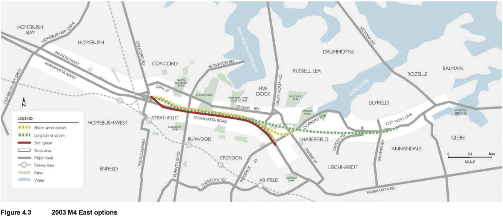
The short tunnel option was preferred for a number of reasons. When compared to the long tunnel option, the short tunnel was considered to have lower costs both during construction and operation (ie lower tolls) and would require fewer ventilation stacks. The long tunnel option was considered to have the potential to increase congestion on the approaches to the Anzac Bridge, including unacceptable queuing back into the eastbound tunnels.
The slot option could be constructed at a similar cost to the short tunnel; however, it was considered to not provide the same level of traffic benefits as the tunnel option. The construction period for this option would be longer, due to the need to acquire a substantial number of properties. The impacts on the community and traffic on Parramatta Road during construction were also considered to make the slot option less attractive.
2012 original WestConnex slot scheme
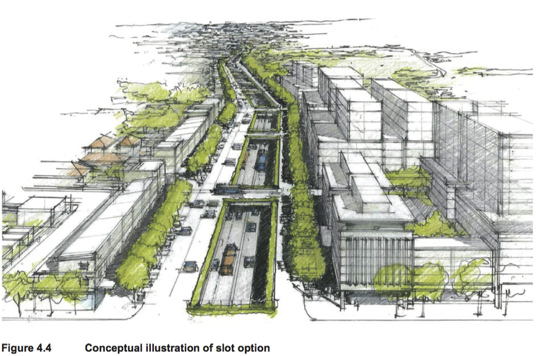
The original WestConnex scheme set out in the State Infrastructure Strategy and WestConnex – Sydney’s next motorway priority (Infrastructure NSW 2012b) comprised a connection between the existing M4 at North Strathfield and Taverners Hill at Petersham.
A key feature of the conceptual scheme was a slotted motorway running parallel to Parramatta Road, to optimise opportunities for urban renewal. Figure 4.4 provides a conceptual il ustration of the proposed slot arrangement as shown in the State Infrastructure Strategy.
2013 industry partner development
Following the advice of Infrastructure NSW for “greater private sector involvement at the design phase” (Infrastructure NSW 2012a), four Australian and international construction industry consortia lead by Ferrovial Agroman, Leighton Contractors, Thiess and Baulderstone/Bouygues were selected as partners to assist with developing improved design and construction solutions for specific sections of WestConnex. Ferrovial Agroman and Leighton Contractors were assigned to the Northern Corridor, from the existing M4 and Parramatta Road at Homebush Bay Drive to Campbell Street at St Peters. Thiess and Baulderstone/Bouygues were assigned to the Southern Corridor, from the M5 to the Airport Link at St Peters.
The purpose of these engagements was to ensure that a wide variety of efficient and innovative options were identified and considered in the development of WestConnex. Preferred options were subject to multi-criteria analysis and further design refinement using traffic, financial and economic evaluation as part of the development of the 2013 business case.
Following the industry partner development process, the slot option was not preferred due to:
- The extent of property acquisition required
-
Complex traffic management and substantial traffic impacts on Parramatta Road during construction
-
Difficulties in managing surface water around and over the open slot.
2013 WestConnex Business Case
In September 2013, the Sydney Motorways Project Office (then part of Roads and Maritime and the precursor agency to the WestConnex Delivery Authority) released the WestConnex Business Case Executive Summary. The M4 East component of WestConnex was proposed to continue the M4 from Homebush Bay Drive to Parramatta Road and City West Link at Haberfield, by providing a tunnel with three lanes in each direction, general y following the alignment of Parramatta Road.
4.3.2 Tunnel corridor options
Three tunnel corridor options were considered and assessed against the project objectives:
- Generally following the alignment of Parramatta Road. This option was included in the concept design that was publicly displayed between 2013 and February 2014
-
North of Parramatta Road for the full length of the project
-
Generally south of Parramatta Road, except for a section at the western end.
The advantages and disadvantages of these options are outlined in Table 4.2.
| Option | Advantages | Disadvantages |
|---|---|---|
| Following Parramatta Road |
|
|
| North of Parramatta Road |
|
|
| Generally south of Parramatta Road |
|
|
Positioning the tunnels generally to the south of Parramatta Road was preferred as ground conditions are general y considered to be better, which would allow for quicker construction and lower risks associated with tunnelling activities. This option would also result in a shorter tunnel length, which would in turn reduce construction cost.
The positioning of the tunnels south of Parramatta Road would also preserve the corridor for future development as part of the Parramatta Road urban renewal strategy. This would allow development along the majority of Parramatta Road to occur without the restriction of a tunnel below.
4.3.3 Number of lanes within tunnels
Three options were considered for the number of lanes within the tunnels, and assessed against the project objectives:
- Two lanes
-
Three lanes. This option was included in the concept design that was publicly displayed between 2013 and February 2014
-
Four lanes.
The advantages and disadvantages of these options are outlined in Table 4.3.
| Option | Advantages | Disadvantages |
|---|---|---|
| Two lanes |
|
|
| Three lanes |
|
|
| Four lanes |
|
|
The construction of three lanes in each direction within the tunnels was the preferred option, as it would match the number of lanes on the existing M4 at Concord and on Parramatta Road at Haberfield/Ashfield. It would cater for projected initial and future traffic volumes within the tunnel (refer to Chapter 8 (Traffic and Transport)).
4.3.4 Preferred motorway option
Having considered the motorway options against the project objectives, the preferred motorway option is for a three-lane tunnel located generally on the southern side of Parramatta Road.
4.4 Interchange options
4.4.1 Western tunnel portals
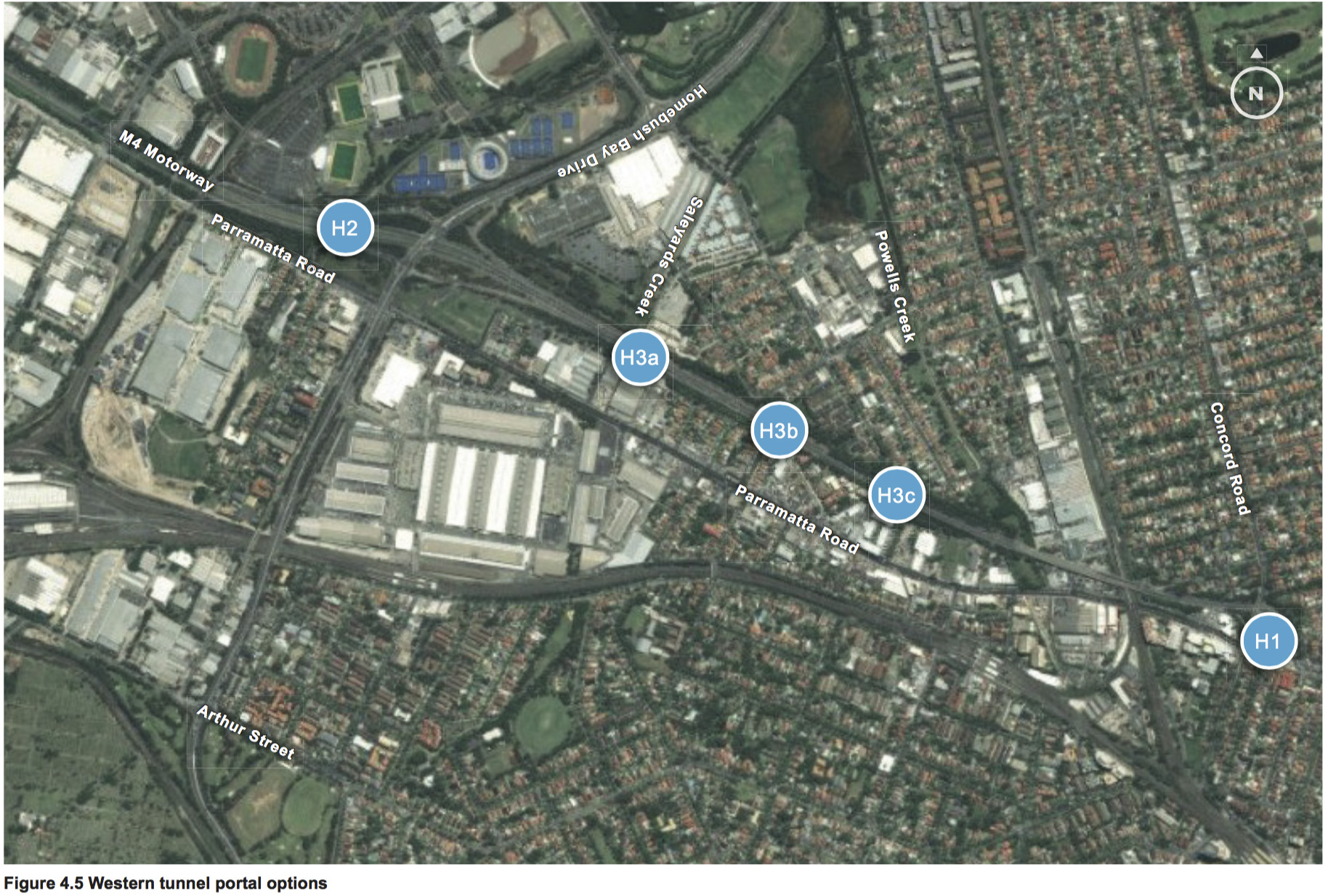
Options considered
The following options were considered for the western tunnel portals:
- Option H1 – Concord Road interchange: This would have involved duplicating the existing M4 viaduct between Underwood Road at Homebush and Queen Street at North Strathfield. The western tunnel portals would form part of the Concord Road interchange
-
Option H2 – west of Homebush Bay Drive: This option would involve locating the western tunnel portals on the western side of Homebush Bay Drive
-
Option H3 – east of Homebush Bay Drive: This option would involve locating the western tunnel portals between Homebush Bay Drive and Powells Creek, but as a separate interchange to the Concord Road interchange. This option would al ow all movements to and from both the existing M4 and Homebush Bay Drive into the mainline tunnels. This option was included in the concept design that was publicly displayed between 2013 and February 2014.
The general location of these portal options is shown on Figure 4.5.
Assessment of options
The advantages and disadvantages of these options are outlined in Table 4.4.
| Option | Advantages | Disadvantages |
|---|---|---|
| H1 |
|
|
| H2 |
|
|
| H3 |
|
|
Preferred option
Option H3, locating the western portals east of Homebush Bay Drive, was selected as the preferred
option, as it would:
- Minimise grade and impacts on residential properties east of Concord Road
-
Not limit future development potential of land at Railway Lane and George Street
-
Connect to the key centres of Sydney Olympic Park and Rhodes.
Location refinement
Once Option H3, between Homebush Bay Drive and Powells Creek, was selected as the preferred
western portal option, a number of design refinements were considered for the location of the portals,
including:
- H3a – near Saleyards Creek
-
H3b – near Bill Boyce Reserve at Wentworth Avenue and Pomeroy Street
-
H3c – near Underwood Road.
The general location of these is shown on Figure 4.5. The selected design refinement was H3b, which is a location to the east of Saleyards Creek, about near the footbridge over the existing M4. This location was selected because it would:
- Avoid areas of flood inundation near Saleyards Creek
-
Maintain the existing pedestrian bridge across the M4
-
Not affect Wentworth Road South or Pomeroy Street on the northern side of the existing M4
-
Allow the tunnel to be far enough below ground so as to not prevent high density development within the Bakehouse Quarter due to potential basements or building footings
-
Utilise land within the existing M4 road reserve.
4.4.2 M4 westbound access options
Options considered
The following options were considered for access to the M4 westbound:
- Option OR1 – retain the existing arrangement: This option would involve retaining the westbound on-ramp to the M4 from Concord Road northbound, retaining the left turn from Parramatta Road eastbound to the M4 westbound, and not providing a new on-ramp
-
Option OR2 – remove the westbound on-ramp to the M4 from Concord Road northbound and the left turn from Parramatta Road eastbound to the M4 westbound, and not provide a new on- ramp: Traffic would be required to access the M4 westbound by either approaching the Parramatta Road and M4 intersection from the east, or using the Homebush Bay Drive interchange
-
Option OR3 – at the intersection of Parramatta Road and Station Street: This option would involve removing the westbound on-ramp to the M4 from Concord Road northbound and the left turn from Parramatta Road eastbound to the M4 westbound, and providing a new westbound on- ramp at the intersection of Parramatta Road and Station Street at Homebush
-
Option OR4 – immediately to the west of Powells Creek: This option would involve removing the westbound on-ramp to the M4 from Concord Road northbound and the left turn from Parramatta Road eastbound to the M4 westbound, and providing a new westbound on-ramp to the west of Powells Creek.
Assessment of options
The advantages and disadvantages of these options are outlined in Table 4.5.
| Option | Advantages | Disadvantages |
|---|---|---|
| OR1 |
|
|
| OR2 |
|
|
| OR3 |
|
|
| OR4 |
|
|
Preferred option
Option OR4, involving an on-ramp adjacent to Powells Creek, was considered the preferred option as it would:
- Provide relief to the intersection of Parramatta Road, Concord Road and Leicester Avenue at North Strathfield
-
Provide an alternate access to the M4 westbound within close proximity to the existing accesses, so as to not significantly increase travel time and affect network performance in other locations
-
Not involve acquisition of privately-owned land.
Location refinement
As a number of options in different locations were considered for the M4 westbound on-ramp, there was no need to consider location refinements during preferred design development.
4.4.3 Concord interchange
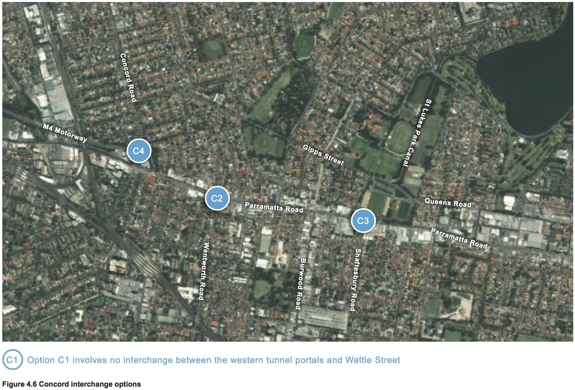
Options considered
The following options were considered for an interchange at or near Concord:
- Option C1 – no interchange: This option would involve having no interchange between the western portals and Wattle Street/Parramatta Road
-
Option C2 – interchange on Parramatta Road near Wentworth Road: This option would involve providing an interchange on Parramatta Road near Wentworth Road at Strathfield and Shaftesbury Road at Burwood. This option would have provided an eastbound on-ramp and a westbound off-ramp
-
Option C3 – interchange on Parramatta Road near Shaftesbury Road: This option would involve providing an interchange on Parramatta Road near Shaftesbury Road at Burwood. This option would have provided an eastbound on-ramp and a westbound off-ramp
-
Option C4 – Concord Road: This option would involve providing an interchange at Concord Road, with an eastbound on-ramp and a westbound off-ramp. Movements to and from the existing M4 would be maintained. This option was included in the concept design that was publicly displayed between 2013 and February 2014.
The general location of these interchange options is shown on Figure 4.6.
Assessment of options
The advantages and disadvantages of these options are outlined in Table 4.6.
| Option | Advantages | Disadvantages |
|---|---|---|
| C1 |
|
|
| C2 |
|
|
| C3 |
|
|
| C4 |
|
|
Preferred option
Option C4, involving an interchange at Concord Road, was considered the preferred option as it would:
- Provide access to the key centres of Strathfield and Rhodes
-
Not involve substantial impacts to commercial and industrial properties on Parramatta Road
-
Not involve unsafe weave movements within the tunnel.
Location refinement
Once Option C4 was selected as the preferred interchange option at Concord, a number of refinements were considered for the location and design of the interchange. The general location of these is shown on Figure 4.6.
Two main designs for the interchange and locations of the on- and off-ramp portals were considered:
- C4a – mostly on the western side of Concord Road, including:
- New northbound and southbound on-ramps connecting Concord Road to the eastbound tunnel
- New northbound and southbound off-ramps connecting the westbound tunnel to Concord Road
- Widening of Concord Road at the on- and off-ramps
- Realignment of the existing M4 between Sydney Street and Parramatta Road
- C4b – mostly on the eastern side of Concord Road, including:
- New eastbound on-ramp and westbound off-ramp connecting the new tunnels to Concord Road (via Sydney Street)
- New westbound exit to Parramatta Road via the existing M4, including modification of the M4 between the Concord Road overbridge and Parramatta Road intersection, and lane changes on Parramatta Road
- Widening of Concord Road to provide extra turning lanes into Sydney Street for the new eastbound on-ramp.
Location C4b would result in acquisition of a large number of properties to the east of the existing M4 associated with cut and cover works for connections to the driven tunnels. This location and design would have resulted in a number of residential properties in Ada Street and Franklyn Street being separated from the remainder of the residential area and facilities such as schools located to the north of Sydney Street. The physical barrier created by the cut-and-cover tunnels would have resulted in impacts on pedestrian connectivity. This concern was raised by a number of residents during early consultation activities for the project. Option C4b was the arrangement included in the concept design that was publicly displayed between 2013 and February 2014.
Location C4a was preferred as it would reduce the length of cut-and-cover tunnels and the number of properties to be acquired on the eastern side of Concord Road. It would, however, increase the number of properties to be acquired on the western side of Concord Road, including a number of heritage items and other dwellings located within a heritage conservation area. Location C4a would also provide connections between the tunnels and Concord Road as left-in and left-out only, which would result in improved traffic performance along Concord Road and at the intersection of Concord Road/Leicester Avenue and Parramatta Road.
As a further design refinement at Location C4a, the existing westbound on-ramp from Concord Road northbound to the M4 would be removed and replaced with a new westbound on-ramp about 500 metres to the west, near Powells Creek. In addition, a new westbound on-ramp would be provided from Concord Road southbound to the M4 westbound. These new ramps would reduce the volume of traffic using the Concord Road/Leicester Avenue and Parramatta Road intersection, and the existing M4 and Parramatta Road intersection.
4.4.4 Wattle Street (City West Link) interchange
Options considered
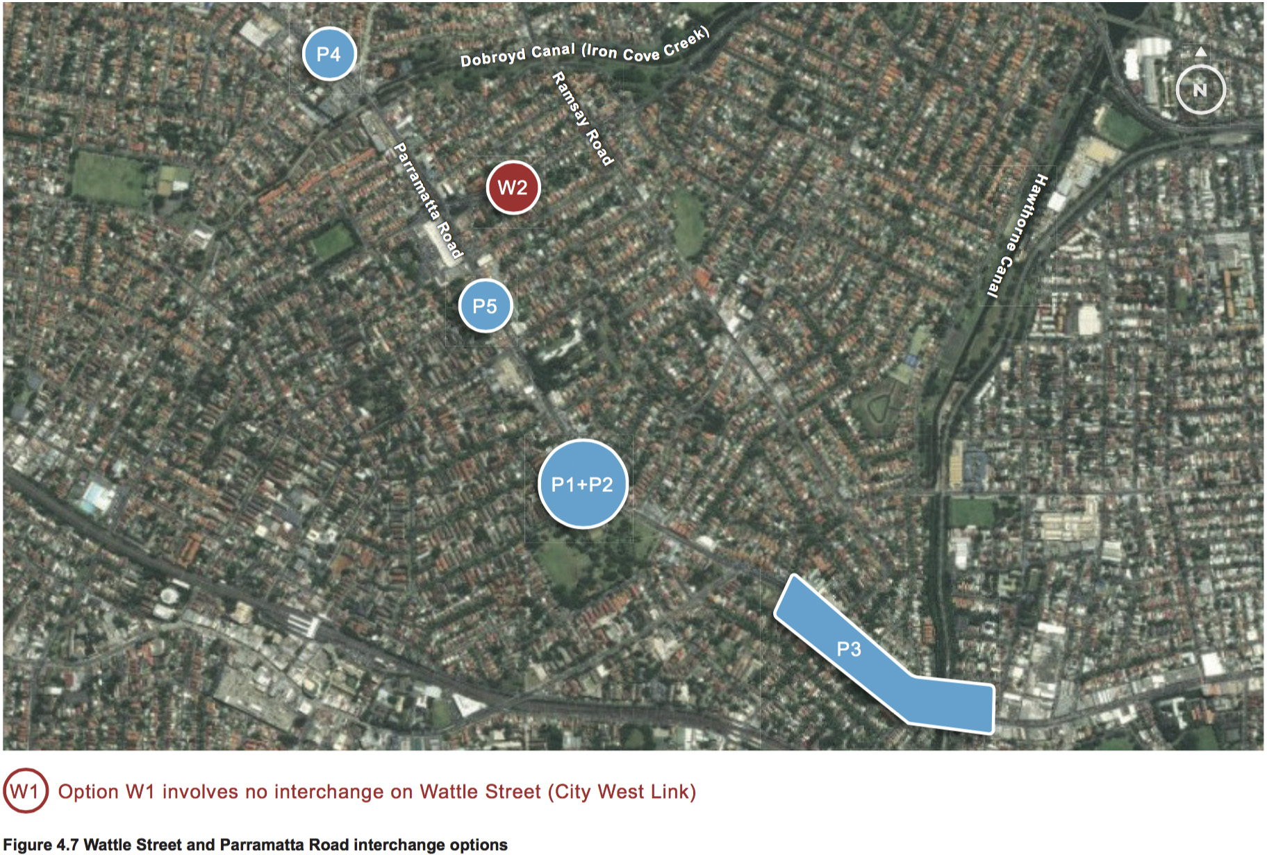
The following options were considered for an interchange at or near Wattle Street (City West Link):
- Option W1 – no interchange: This would involve not providing an interchange to Wattle Street (City West Link), and would mean there would only be an interchange to Parramatta Road at the eastern end of the project
-
Option W2 – interchange at Wattle Street (City West Link): This option would involve providing on- and off-ramps from the mainline tunnels to Wattle Street (City West Link). This option was included in the concept design that was publicly displayed between 2013 and February 2014.
The general location of these interchange options is shown on shown on Figure 4.7.
Assessment of options and preferred option
The State Infrastructure Strategy proposed a Western Harbour Tunnel that would connect Rozelle with the Warringah Freeway on the lower north shore. It would relieve pressure on the Harbour Bridge, the Anzac Bridge and the Eastern Distributor, and would complement and strengthen the benefits of the WestConnex scheme. As a result, rather than travel under Parramatta Road, the concept alignment of the M4–M5 Link was modified to travel north, connecting to the Western Harbour Tunnel, before turning south and connecting to the New M5 at St Peters.
This change in alignment of the M4–M5 Link meant that a connection to Wattle Street (City West Link) was required. Therefore Option W1 was not considered further, and Option W2 was the preferred option.
Location refinement
Once Option W2 was selected as the preferred interchange option at Wattle Street, a number of refinements were considered for the design of the interchange. The location of the on- and off-ramp portals for all design refinements was near Ramsay Street.
The following design options for the interchange were considered:
- W2a – eastbound off-ramp and westbound on-ramp only, to be constructed as part of the project
-
W2b – eastbound off-ramp and westbound on-ramp, as well as eastbound on-ramp to and westbound off-ramp from the M4–M5 Link, to be constructed as part of the project.
Design refinement W2b was preferred, as it would involve all infrastructure associated with the WestConnex scheme (both M4 East and the M4-M5 Link) near Wattle Street and Ramsay Street being constructed at the same time, reducing the impacts of construction in this area.
4.4.5 Parramatta Road interchange
Options considered
The following options were considered for an interchange at Parramatta Road:
- Option P1 – interchange with M4 East near Ashfield Park: This option would provide an eastbound off-ramp and westbound on-ramp near Ashfield Park
-
Option P2 – interchange with M4 East and M4–M5 Link near Ashfield Park (the same location as Option P1): This option would provide an eastbound off-ramp and westbound on-ramp, as well as an eastbound on-ramp to and westbound off-ramp from the M4–M5 Link near Ashfield Park, to be constructed as part of the project. This option was included in the concept design that was publicly displayed between 2013 and February 2014
-
Option P3 – interchange with M4 East and M4–M5 Link at Taverners Hill: This option would provide an eastbound off-ramp from and westbound on-ramp to the M4 East near Sloane Street at Haberfield/Summer Hill, as well as an eastbound on-ramp to and westbound off-ramp from the M4–M5 Link near Flood Street at Leichhardt, to be constructed as part of the project. This option would include either a tunnel to Flood Street or a substantial viaduct from Haberfield Road to Flood Street, over Hawthorne Canal, connecting the project to the M4–M5 Link
-
Option P4 – interchange with M4 East and M4–M5 Link west of Wattle Street: This option would provide an eastbound off-ramp and westbound on-ramp, as well as an eastbound on-ramp to and westbound off-ramp from the M4–M5 Link on the western side of Wattle Street, to be constructed as part of the project. This option was considered in conjunction with Option W1, which did not include an interchange at Wattle Street (City West Link)
-
Option P5 – interchange with M4 East near Bland Street: This option would provide an eastbound off-ramp and westbound on-ramp near Bland Street. On- and off-ramps to and from the M4–M5 Link would not be provided under this option.
The general location of these interchange options is shown on Figure 4.7.
Assessment of options
The advantages and disadvantages of these options are outlined in Table 4.7.
| Option | Advantages | Disadvantages |
|---|---|---|
| P1 and P2 |
|
|
| P3 |
|
|
| P4 |
|
|
| P5 |
|
|
Preferred option
Option P5, involving an interchange near Bland Street, was considered the preferred option. It would not involve impacts on Ashfield Park and Yasmar, and would not create unacceptable traffic impacts on the Wattle Street/Parramatta Road/Frederick Street intersection. The change in alignment of the M4–M5 Link to connect with the proposed Western Harbour Tunnel removed the need to provide an eastbound on-ramp or westbound off-ramp at this location.
Location refinement
As a number of options in different locations were considered for the Parramatta Road interchange, there was no need to consider location refinements for the preferred Parramatta Road interchange option during concept design development.
4.5 Design development of ancillary facilities
4.5.1 Ventilation system design
On an open roadway, vehicle emissions are diluted and dispersed by natural surface flows. A tunnel is defined in NSW as an enclosed roadway that is greater than 120 metres in length and all tunnels in NSW are unidirectional, meaning that traffic travels in one direction only within the tunnel. Usually two tunnels are constructed side by side (for example, the Lane Cove tunnel), or one on top of the other (for example, the Eastern Distributor), to enable traffic to travel in both directions.
The basic function of tunnel ventilation is the dilution of vehicle emissions by providing fresh air to, and removing exhaust air from, the tunnel. The movement of vehicles through a tunnel drives air flow, called the ‘piston-effect’, drawing fresh air in through the tunnel entrance, diluting the vehicle exhaust emissions. In short tunnels up to around 500 metres long, this volume of fresh air is usually adequate to manage in-tunnel air quality. In longer tunnels, under some circumstances, additional air may need to be forced through the tunnel by fans to dilute emissions and maintain appropriate air quality.
The requirements for tunnel ventilation are determined by the vehicle emissions in the tunnel and the limits of pollutant levels set by regulatory authorities. The levels of pollutants increase along the length of the tunnel as vehicles generate emissions as they travel through the tunnel. Air quality is managed by ensuring that the volume of fresh air coming into the tunnel adequately dilutes the pollutants. For longer tunnels the flow of fresh air can be supplemented where required by ventilation fans or by air exchanges which remove exhaust air and/or supplies additional fresh air depending on tunnel size and length and number and mix of vehicles. Elevated ventilation outlets are used for longer tunnels in urban areas to disperse tunnel air to protect local air quality.
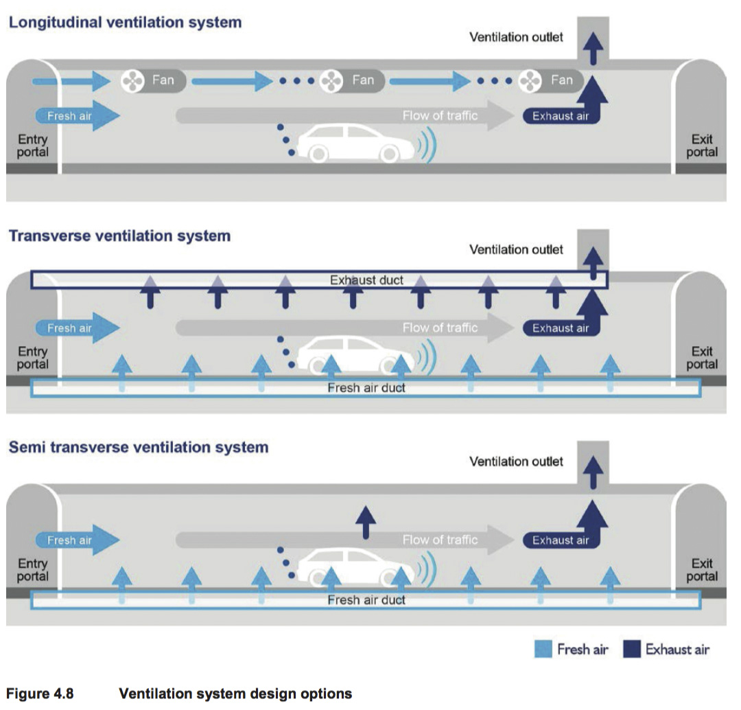
A number of options for design of the ventilation system were considered. The advantages and disadvantages of the various systems are described below, and shown in Figure 4.8. Further discussion on the ventilation system can be found in Chapter 9 (Air quality).
Longitudinal ventilation
The simplest form of ventilation is longitudinal ventilation in which fresh air is drawn in at the entry portal and passes out through the exit portal with the flow of traffic. For longer tunnels, the air flow is supplemented by fans that are used when traffic is moving too slowly to maintain adequate air flow, or to draw air back from the exit portals against the flow of exiting traffic. This air is then exhausted through an elevated ventilation outlet to maximise dispersion into the outside air. All road tunnels built in Australia in the last 20 years have been designed and operated with longitudinal ventilation systems.
Transverse ventilation
Another way to ensure adequate dilution of emissions is to provide fresh air inlets along the length of the tunnel along the side and to balance the amount of air coming in, outlets on the opposite of the side. This system requires two ducts to be constructed along the length of the tunnel: one for the fresh air supply and for the exhaust air. Transverse ventilation has been used in the past when vehicle emissions produced greater levels of pollutants than they do today in Australia. A transverse ventilation system is more expensive to construct because of the additional ducts that need to be excavated for each tunnel. This type of system is less effective than a longitudinal system at controlling smoke in the tunnel in case of a fire.
Semi transverse ventilation
Semi-transverse ventilation combines both longitudinal and transverse ventilation. Fresh air can be supplied through the portals and be continuously exhausted through a duct along the length of the tunnel. Alternatively fresh air can be supplied through a duct and exhausted through the portals.
Ventilation outlets
Currently a key operating requirement for the longer tunnels opened in Sydney since 2000, is to minimise emissions through the portals, or tunnel entrances. Essentially this means that the ventilation systems are designed to have zero portal emissions with all air being expelled through an elevated ventilation outlet. Air is drawn in from all the portals, including the exit portals where it is drawn against the flow of traffic. The ventilation system is more complex than it would be if portal emissions were permitted with more fans required and with higher capital and operational costs
Drawing air from the exit portal increases the quantity of ventilation air to be discharged through the ventilation outlet and can significantly increase the diameter of the outlet required. Zero portal emissions also means that the ventilation system needs to be operating all the time regardless of whether in-tunnel or ambient air quality warrants this operation.
Summary
The development of cleaner vehicles in response to cleaner fuel and emissions standards means that a significant reduction in vehicle emissions has occurred over the past 20 years. Longitudinal ventilation was once not suitable for long tunnels due to the need to supply large volumes of fresh air to dilute vehicle emissions. A well-designed longitudinal ventilation system can now easily maintain acceptable air quality in long tunnels and is considered the most efficient and effective tunnel ventilation system (Roads and Maritime 2014c).
Although all three ventilations systems could be designed to ensure that in-tunnel air quality criteria would be met, a longitudinal system has been selected for the project. Longitudinal ventilation is less costly to construct and to operate than transverse systems and, importantly for fire and life safety, is more effective for management of smoke in a tunnel.
Discharging tunnel air through an elevated ventilation outlet ensures that it is dispersed and diluted so that there is minimal or no effect on ambient air quality. The effectiveness of elevated ventilation outlets in dispersing emissions is well established. Chapter 9 (Air quality) presents the air quality assessments for both in-tunnel and external air quality.
The preferred ventilation system is longitudinal ventilation with elevated ventilation outlets.
4.5.2 Ventilation facility locations
The main considerations in relation to ventilation facilities are; minimising local air quality impacts on nearby receptors and maximising the operational efficiency of the tunnel ventilation system. Minimising local air quality impacts is primarily achieved through the design and operation of the ventilation outlet and is relatively insensitive to the location of the outlet for similar landform and surrounding development. The location of road tunnel ventilation outlets is very important for the efficiency of the tunnel ventilation system.
Background and design considerations that affect location
As described in section 4.5.1, vehicles travelling through tunnels create a piston effect, whereby the movement of vehicles draws air into the tunnel system through the entrance portals, with emission levels rising toward the tunnel exit in a tunnel with longitudinal ventilation as proposed for the project. A longitudinal system relies on single directional traffic flow, and therefore separate tunnels for eastbound and westbound traffic would be required. This also results in the need for a ventilation outlet at each end of the project, with at least one outlet for each tunnel.
No portal emissions are proposed for the project. This is unique to recent Australian road tunnels, with no international precedence for this approach to ventilation design. Zero portal emissions essentially requires that no air (pol uted or otherwise) can be allowed to exhaust from the tunnel exit portals (or entry portals). This affects the design and location of the ventilation exhaust points and outlets.
The ventilation outlet needs to be located close to but not at the end of the tunnel exit portals. This is to allow some air to be drawn into the portals against the traffic flow. This forced reverse flow is achieved by jet fans positioned within the tunnel. Minimising the use of these fans increases the performance of the tunnels, reduces operational power consumption and thus reduces the cost associated with operation. This also has environmental benefits, by reducing greenhouse gas emissions associated with energy generation.
Western ventilation facility
The western ventilation facility would be located above the cut-and-cover section of the westbound mainline tunnel west of Underwood Road, avoiding the need for additional property acquisition. The requirement for zero portal emissions means that the ventilation outlet cannot be located right at the portal, because of the difficulty this would cause for managing air flow at this location. The location of the western ventilation facility is 200 metres from the western tunnel exit portal, optimising the distance over which air is drawn back from the portal while ensuring that there would be zero portal emissions. It would also not be possible to locate the facility closer to the tunnel portal given the presence of surface road infrastructure at this location.
The location of the western ventilation facility has also considered the potential future high rise residential redevelopment at Homebush north of the M4, which is contemplated in the New Parramatta Road: Draft Parramatta Road Urban Renewal Strategy (UrbanGrowth NSW 2015).
Potential alternative locations for the western ventilation facility were considered as follows:
- Above the westbound tunnel further to the west – while this would be closer to the tunnel exit portal, it would conflict with the realigned surface M4 in this location. As described above, it is not possible to locate the exhaust point at the end of the tunnel exit portal
-
Above the westbound tunnel further to the east – this would increase the distance from the tunnel exit portal, and would require additional reverse flow jet fans to draw the air back to the ventilation outlet
-
At one of the sites near Underwood Road proposed to be used as a construction ancillary facility (refer to Chapter 6 (Construction work)) – these sites would be closer to a greater number of residential dwel ings, and would increase the distance from the tunnel exit portal, requiring additional jet fans.
It was therefore considered that there are no other feasible and reasonable alternatives for the location of the western ventilation facility.
On this basis, the preferred option for the western ventilation facility was selected as above the cut- and-cover section of the westbound mainline tunnel west of Underwood Road. This location was considered to best meet the main considerations of minimising local air quality impacts on nearby receptors and maximising the operational efficiency of the tunnel ventilation system.
Eastern ventilation facility
Number of ventilation outlets
The design of the eastbound tunnel and ventilation facility has been determined by the requirement for:
- Eastbound exit portals to Wattle Street and Parramatta Road
-
A possible future connection to the M4–M5 Link
-
A possible future westbound exit onto Wattle Street from the M4–M5 Link.
This results in the need for five ventilation exhaust points, one for each off-ramp and two at the M4– M5 Link interface (one for each direction). The number of outlets is determined by the road geometry not the level of pollutants in the tunnel.
Based on the design considerations that affect the location of ventilation facilities discussed above, it may seem that the most efficient location of the outlets would lead to five separate ventilation outlets. This is not the case for the eastern ventilation facility because of the staging of WestConnex. At the completion of project, all of the air would be required to be exhausted from the Wattle Street and Parramatta Road off-ramps, because the M4–M5 Link would not yet be constructed and all of the traffic will use the off-ramps. Once the M4–M5 Link is complete (if approved), the required capacity of the Wattle Street and Parramatta Road off-ramps to exhaust air from the mainline tunnels would be reduced as the majority of air would continue through the mainline tunnels. Due to the project staging, a combined ventilation outlet for both the M4 East and M4–M5 Link projects would have a total exhaust capacity which is less than the total exhaust capacity if each ventilation outlet was separate. Other advantages include not having to acquire additional land, build separate structures, or provide separate power supply. The disadvantages of a combined outlet are additional underground tunnelling for ventilation ducts and a reduction in air flow efficiency because of these ducts.
Consideration was given to this ventilation facility only servicing the current project only (and not the M4-M5 Link as well). This would have meant that a second, separate ventilation facility would need to be constructed at another location near the M4–M5 Link tunnel portals (if approved), potentially involving additional property acquisition and two separate periods of construction would be required within a few years. This was considered to have an unacceptable impact on residents in this area, and two separate periods of construction would be needed within a few years.
Location
The location of the eastern ventilation facility, on the north-eastern corner of the Wattle Street and Parramatta Road intersection, provides optimal ventilation performance for both the project (including the mainline tunnels and the Wattle Street and Parramatta Road off-ramps) and the M4–M5 Link (including the mainline tunnels and the Wattle Street off-ramp). The air quality assessment (see Chapter 9) shows that the ventilation outlet at the proposed location has minimal impact on nearby community receptors such as Haberfield Public School.
Other locations considered for the eastern ventilation facility, and the reasons they were discarded, were:
- On the south-eastern side of the Parramatta Road and Frederick Street intersection (the Bunnings site) – this would have involved impacts on a locally listed heritage item. Consideration was given to incorporating the ventilation outlet within the clock tower at this building; however, it is not sufficiently high or wide to meet operational needs and achieve air quality goals. Bunnings is a major local employer and construction of the ventilation facility at this location would have required acquisition of the property and relocation or closure of the Bunnings store
-
On the south-western side of the Parramatta Road and Frederick Street intersection – this would increase the distance from the tunnel exit portals, and would require additional reverse flow jet fans to draw the air back to the ventilation outlet. It would also involve the acquisition of residential properties in Earle Avenue at Ashfield that are located within The Ranch heritage conservation area
-
On land identified for use during construction of the project at Northcote Street, west of the Wattle Street intersection – this option would utilise land to be acquired for construction purposes. However this would mean that construction of the ventilation facility could not commence until tunnelling works are complete, extending the duration of construction and delaying project commissioning
-
On land identified for use during construction of the project along Parramatta Road, further to the east – this would have been located a significant distance from the Wattle Street on- and off- ramps, resulting in the need to reverse air flow by jet fans through longer sections of tunnel, with increased energy use
-
On land identified for use during construction of the project along Wattle Street, further to the north-east – this would have been located a significant distance from the Parramatta Road off- ramp, resulting in the need to reverse air flow by jet fans through longer sections of tunnel with increased energy use.
On this basis, a combined ventilation facility for the project and the possible future M4–M5 Link located on the north-eastern corner of Wattle Street and Parramatta Road was selected as the preferred option. It was considered to best meet the main considerations of minimising local air quality impacts on nearby receptors and maximising the operational efficiency of the tunnel ventilation system. It would also minimise cumulative impacts of construction on the local community.
4.5.3 Emergency smoke exhaust facility
A key aspect of safe tunnel operation is the efficient removal of smoke in the event of a fire in the tunnel. One option to achieve this in long tunnels is to provide an emergency smoke exhaust facility.
The need for an emergency smoke exhaust facility was considered during the development of the project. An emergency smoke exhaust facility was included in the preliminary concept design. Following design development and in consultation with relevant agencies (eg Fire & Rescue NSW), such a facility was considered to not be required.
4.5.4 Fresh air supply facility
The project includes the construction of a fresh air supply facility in the vicinity of Cintra Park at the mid-point of the tunnels which could potentially reduce the number of jet fans required in the tunnels. This facility would allow fresh air to be introduced into the tunnels. Table 4.8 outlines the alternative locations that were considered for the location of the fresh air supply facility.
| Location | Advantages | Disadvantages |
|---|---|---|
| Cintra Park |
|
|
| Concord Oval |
|
|
| St Lukes Park and Cintra Park north of Gipps Street |
|
|
| Burwood Bus Depot |
|
|
| Residential and/or commercial properties |
|
|
Cintra Park was considered to be the preferred location for the fresh air supply facility as it would use land that would be acquired for construction of the project. This would minimise the amount of open space, commercial and residential properties acquired by the proposal. The extent of permanent works would not prevent this land would be returned to Canada Bay Council and being used for open space in the future.
4.5.5 Motorway control centre
Each WestConnex project would require a control centre to monitor and manage the operation of the motorway and, where relevant, tunnels.
The respective merits of a stand-alone control centre for each stage, or a single control centre for all projects, have been considered. Should the separate components of WestConnex be operated by different operators, a stand-alone control centre for each stage would be preferred. Should WestConnex be operated by a single operator, a combined motorway control centre could be constructed. In this case, the motorway control centre constructed for the M4 East project would be used as a backup facility.
The proposed motorway control centre of the project would be located on the northern side of the existing M4 to the east of Homebush Bay Drive and south of the Ausgrid Mason Park substation. Access to the centre would be from the eastbound M4 on-ramp at Homebush Bay Drive.
This site was considered the best option for the location of the centre as it would make use of residual land that is required during construction but not during operation of the project. This would mean that additional residential, commercial or open space land would not need to be acquired. The location of this residual land adjacent to the M4 and near the eastbound mainline tunnel portal also means that access to the motorway would be readily available for emergency response and maintenance vehicles and equipment that would be stored at the site in the adjoining maintenance facility and bulky equipment store.
4.6 Construction methodology development
4.6.1 Tunnel construction methods
A number of options for tunnel construction methods were considered. The advantages and disadvantages of the various methods are described below.
Tunnel boring machine
A tunnel boring machine (TBM) is a specialist machine which excavates a circular bore of fixed diameter by rotary action. The machine comprises of a rotating head fitted with disc cutters, drag bits and clay spade. Soft ground TBMs include a facility for the fixing of fabricated permanent wall lining panels (generally precast concrete) immediately behind the cutting face. Hard ground (rock) TBMs include a gripper facility that allows the TBM to push off the wall of the excavation. The TBMs are normally custom made to suit the particular requirement of the individual project and require considerable time to deliver and mobilise for full operation. They also require a large open area on site to assemble and align in position for driving.
Drill and blast
The drill and blast excavation method involves a sequence of the dril ing of holes, charging the holes with explosive, blasting, mucking out and instal ing the roof and wall ground support. The method is an efficient and cost effective way of excavation of rock, providing an effective tunnel excavation method assisting in achieving an overall shorter project delivery. This method of excavation offers the shortest exposure to noise and vibration for residents and businesses above the tunnels compared to other methods of tunnel excavation.
Road header excavation
A road header is a commonly used machine for excavation in sandstone and has been successfully used in recent tunnel projects in Sydney. It is a specialist tunnelling plant, which excavates with picks mounted on a rotary cutter head attached to a hydraulically operated boom. In areas of very hard rock, ripper dozers and rock breakers would also be used to assist with the excavation. The excavated material would be continually removed by conveyors onto special dumpers designed to operate in an underground environment. The excavated material would then be stockpiled near the tunnel access where it would be removed from via truck to disposal or reuse locations. As the excavation advances, ground support would be installed behind the excavation face. The support could be permanent or temporary and would normally include rock bolts, steel mesh and sprayed concrete.
Preferred tunnel construction method
A combination of road header excavation and dril and blast was chosen. A heading about six metres high would be excavated with a road header and then a bench of about 1.8 metres deep would be excavated using drill and blast. Ramps would be excavated in two passes with a road header.
The combination of using both road header and drill and blast techniques was selected for the following reasons:
- The combination of methods speeds up excavation compared to work being undertaken solely with the use of road headers
-
It is more economic due to reduced time taken for excavation
-
It reduces the noise and vibration impacts on residential and commercial properties to shorter periods due to the short impacts associated with blasting
-
Geological conditions along the alignment are suitable for both methods to be used.
4.6.2 Spoil disposal
Construction of the project would generate around 2.4 million bank cubic metres of spoil. As described in Chapter 6 (Construction work), spoil reuse and disposal would be prioritised in accordance with the following hierarchy:
- Within the project for earthworks fill
-
Environmental works/community works
-
Development works/land restoration.
As the project comprises predominantly a road tunnel, there are limited opportunities for use of spoil within the project for earthworks fill. On this basis, Chapter 6 identifies the currently proposed locations for spoil use and disposal, all of which are in western Sydney. Consideration has been given to the various modes available to transport this spoil to the reuse or disposal location, and included rail, barge and truck. Table 4.9 outlines the advantages and disadvantages of each of these transport mode options.
| Disposal Method | Advantages | Disadvantages |
|---|---|---|
| Rail |
|
|
| Barge |
|
|
| Truck |
|
|
Spoil removal and disposal using trucks was considered to be the preferred option as it would involve transporting material from the construction site directly to the final disposal location. This option would streamline the handling of spoil (removes double and potentially triple handling spoil), but would result in a higher number of trucks on the road. This increase in truck numbers is not considered to be any more significant than the alternatives, since other transport options (rail and barging) would still require trucks to initially move material to the loading facility and, potentially, to the final destination.
